The Earthly Paradise
by C.S. Forester

Rand MacNally-Cosmopolitan
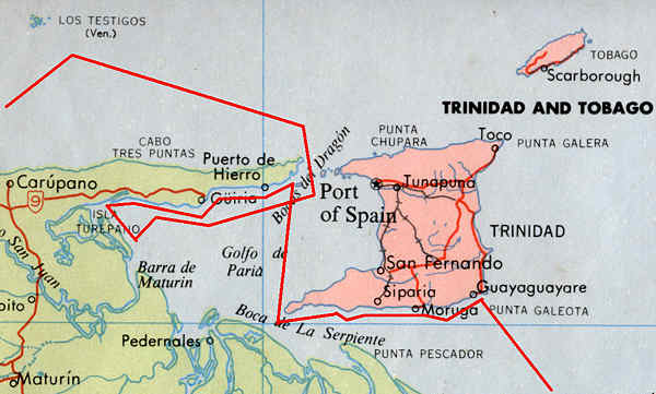
West Indies and the Caribbean 10N 62W
One of the rare cases where the good man gets all mixed up


I was so amazed that I had to check and recheck. And then some.
The book follows a Spanish lawyer who accompanies Columbus on his Third Voyage, and back with Columbus in chains. A fine dramatization of the great Renaissance revolution of which the discovery of America was an important part.
CSF's mix-up starts when Columbus approaches Trinidad from the East, sees three mountains and names it after the Holy Trinity (his capitals). When our lawyer finally gets the island in view, he sees no such hills and starts to doubt Columbus - especially when Columbus immediately dubs it the biblical Land of Ophir.
But Columbus biographer Morison claims that Columbus approaches from the South East, and on the SE corner of the island there are three hills.
CSF has the ship land a boarding party on Trinidad, it's not clear to me where exactly; after the first night they sail West along the Southern coast, to enter the Boca de la Serpiente (serpent's mouth) next morning. The land to the South Columbas called Isla de Gracia. He never knew he had found a continent. Not so strange; only in that same year India was for the first time reached by sea from the West, by Portuguese Vasco da Gama. Only the vaguest ideas existed about the size and shape of Asia.
CSF Chapter Seven begins thus:There was a very markedly northern current along this eastern shore of Trinidad.But we can only be at the Western shore, having passed through the Serpent's Mouth from the East. And CSF has them arrive at the Boca del Dragón (dragon's mouth), where Columbus does not risk the passage and continues East, following the Isle of Grace. But that's West!
Then, they leave them to starboard while they sail easterly (but that's West!), leaving the North-East corner of Trinidad. That's across the island; their position must be at the NW point. They now steer South as there is land on the North, East and West. They can only be in the Golfo de Paria, then, to the West of Trinidad. Eventually they land another boarding party, the first occasion when a European, unknowingly, set foot in South America, never mind Vespucci's claims. Finally, Columbus makes a search party look for a passage West - in the Orinoco. He cannot believe it is a river - those must be islands. (It says so right here in the bible.)
Finally Columbus decides to leave through the Dragon's Mouth. "Close-hauled, they reached to the Southward" - with the eastern Trade Wind, going to the NW? And now, finally, CSF finds the NW corner of Trinidad on their right hand. Right. You have to watch those little details. Once through the passage, they see the coast of Paria (Venezuela) on their right hand. Wrong again.
From there on, CSF gets his act together. No more foolish mistakes.


