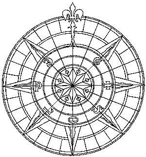
Compass Rose
Spain 1540
old navigation aids
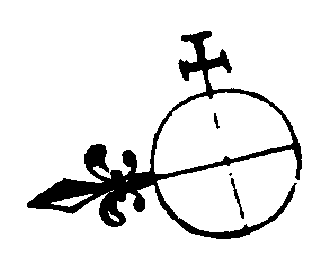
Quadrant - Armilla - Sextant
It took me a big chunk of lifetime to find out what these sailors actually meant when they said "One point West" or used similar quaint expressions. If you're smarter than I am and have known all about this long since, go chase some guys/dolls or have another drink. Otherwise, read on.
It all started with the Babylonians who, for reasons which may have looked good to them, used mathematics based on the number 12. This may sound pretty clumsy to us, but it actually seems not so awkward in practice (no doubt you get used to it after a while).
Anyway, as these guys were the first astronomers worth the name, this explains why our days are 2 times 12 hours long; and also why the earth is divided by 2 x 180 degree meridians. It's a fair guess it also may have to do with the fact that it's easy to construct angles of 30, 60, 45 and 90 degrees and bisect them; but nobody has been able to construct a 100 degree angle. Which again may have influenced their, then after all not so odd, base 12 choice. And vice versa. I'll freely admit getting confused when having to figure in radians, not degrees.
This is the measuring system that will hold its own longest versus metric. For example, 1 nautical mile at the equator equals 1 minute on the map; rather easy, that, when you're navigating. Anyway, a year inconveniently does have 365.25 days; while the moon, embarrassingly, insists on turning round the earth more than 12 times a year, wreaking havoc on tide tables.
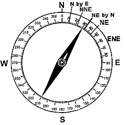
Now for the compass rose. It points North after a not even very old convention; in building and civil engineering drawings it's still quite usual to find it pointing away in any old direction, as long as it fits the paper.
On old maps the North symbol was often augmented with a cross pointing to the Levant
at least, it did as long as you didn't happen to be in the Eastern hemisphere.
But of course, the cross did point to the sunrise, where many religions are based on
The rose points North because a magnetic needle points there; figures. The rose is then divided in 4 quarters (North, East, South, West - we're talking clockwise, called so as most of us are right-handed and wind a clock spring that way); these are bisected again (NE, SE, SW, NW).
Further, we do not have sections of 30 degrees, but of 45/2=22.5 degrees. These are called NNE, ENE etc. And finally, these are bisected once again, and all those resulting marks at 11.25 degrees are the so-called "compass points". Still later, when the efficiency of sail ships improved, they used "half-points" but, wisely, refrained from giving them names.
With the needle pointing to 30 degrees, your ship, boat or bike is moving in the (360-30=) 330 degrees direction (where the needle points to: N).
To take a reading, adjust the graduated circle until 0 coincides with the needle, and there you are - or go.
To sum it all up:If you feel degrees are easier, so does everybody. They tell me it's as good as impossible to actually navigate a sailing ship with any greater accuracy than 1 point, which explains why it took to the end of the 18th century before compass roses with 360 degrees intersections came into use. A halfway decent DC-3 pilot took corrective action long before his aircraft had wandered off course for 5 degrees. Not that 1, 2 or 3 degrees made any difference, except for maybe? surveyors.
N NbyE NNE NEbyN NE NEbyE ENE EbyN 0 11.25 22.5 33.75 45 56.25 67.5 78.75 E EbyS ESE SEbyE SE SEbyE SSE SbyE 90 101.25 112.5 123.75 135 146.25 157.5 168.75 S SbyW SSW SWbyS SW SWbyW WSW WbyS 180 191.25 202.5 213.75 225 236.25 247.5 258.75 W WbyN WNW NWbyW NW NWbyN NNW NbyW 270 281.25 292.5 303.75 315 326.25 337.5 348.75 Dig this quote from Ernest K. Gann's The High and the Mighty: The navigator of a DC-4 remarks:
The compass rose was overlaid, after the compass had come in use, on the wind rose, earlier developed in the Mediterranean by the Phoenicians. The wind rose points pointed in the general direction of eight kinds of winds usual in that area. It seems obvious that, to be of any use, navigators had to be able to distinguish between those winds somehow; at least, that's the story. Humidity? Temperature? Mind boggling. Hard to believe. Maybe this is the solution: Their sailing ships, at night, navigated by the stars. It would be the most accurate solution available to keep steering, in daytime, in the same direction relative to wind direction as at sunrise, for which a wind rose is a pretty good instrument. For those who wonder why it's called aUs amateurs don't really know the way to San Francisco. Now some experts might go so far as to pick forty-nine degrees for a course and get there eventually. But it just so happens I'm fifty-one years of age this month and I can't think of any other number.rose: look at the way the flower's leaves intersect—or think ofrosette, like of an agave plant.
more compass rose illustrations
Also note North by Northwest really doesn't make sense as a compass point.
you may be looking for the
compass used in geometry
PUZZLE!
A hunter leaves his camp and goes 10kms South, where he finds the spoor of a bear, running West.
He follows it for 10kms and shoots the ferocious animal, and takes it to his camp North for 10kms.
What color is the bear? (before he's done skinning it)
even better puzzles!
One thing I can't stop myself from mentioning is that the Dutch refer to "compass points" as windstreken. They then go on to say Hij heeft me een mooie streek geleverd for "He plaid a cute trick on me", where "trick" = "point". Those Dutch sailors didn't seem to have much confidence in wind reliability, and they may have been right. The Dutch language is full of sea terms anyway, often taken from English (the other way round is quite usual too). But Dutch is a funny, if ugly, language: Just have a look at the names they knowingly inflicted upon themselves.

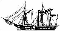
Steamship Curaçao |
Chart Room
|
the European discovery:
|
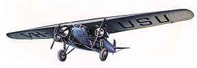
KLM Fokker F-VIIb Snip
|
 |
 |
 |
|
record first Atlantic crossing, 1826
|
old maps
|
comic strip heroes
|
first Trans-Atlantic air service, 1922 |


 copyright notice